
Starved Rock: A History Worth Knowing
- starvedrockhikers
- Feb 8
- 4 min read
On any given weekend, Starved Rock State Park is full of life. Hikers line the trails, cameras point toward canyon walls, and voices echo through the trees. It is hard to imagine that this same landscape once stood largely untouched, with no paths to follow and no signs pointing the way. Long before it became a state park, Starved Rock was a place of movement, shelter, and strategic importance, shaped by glaciers, water, and thousands of years of human presence.

A landscape shaped long before people arrived
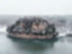
The story of Starved Rock begins long before written history. More than 14,000 years ago, as glaciers retreated at the end of the last Ice Age, meltwater surged across the region. That powerful flow carved through layers of St. Peter Sandstone, forming the steep cliffs, deep canyons, and broad river valley that define the park today.
Unlike many waterfalls that flow year round, Starved Rock’s waterfalls are rain fed. After storms or during spring snowmelt, water spills over canyon rims and down vertical walls, constantly reshaping the rock. Over time, this process created 18 distinct canyons, each with its own character, light, and seasonal changes. The Illinois River below became a natural corridor, guiding both wildlife and people through the landscape.
Early inhabitants and the river corridor
For more than 10,000 years, people have lived in and moved through this area. The river provided food, transportation, and trade routes, while the bluffs offered protection and clear vantage points. Archaeological evidence shows that several cultures thrived here over time, including the Hopewellian, Woodland, and Mississippian traditions.
Among the most recent Native peoples to live in the area were the Illinois people, a confederation made up of several tribes, including the Kaskaskia. Their main settlement, known as the Grand Village of the Kaskaskia or La Vantum by the French, was located directly across the Illinois River from present day Starved Rock. The river valley supported farming, hunting, fishing, and trade, and the bluffs served as both landmarks and places of refuge.
Exploration and early European presence
In 1673, French explorers Louis Jolliet and Father Jacques Marquette traveled through the Illinois River Valley while mapping new routes through the region. Marquette returned two years later and established the Mission of the Immaculate Conception near the Kaskaskia village, marking the first Christian mission in what would later become Illinois.
Recognizing the strategic importance of the high sandstone bluff overlooking the river, the French built Fort St. Louis on top of Starved Rock during the winter of 1682 to 1683. From this elevated position, the fort offered protection, visibility, and control over river traffic. For a time, it served as a gathering place for traders, trappers, and allied tribes.

As conditions changed and resources became harder to sustain, the fort was gradually abandoned. By the early 1700s, French settlers had moved north toward present day Peoria, and by 1720, Fort St. Louis had disappeared from the landscape, reclaimed by weather and time.
The origin of the name Starved Rock
The name Starved Rock comes from a long told Native American legend passed down through generations. The story centers on conflict between tribes in the late 1700s and describes a group seeking refuge atop the sandstone butte now known as Starved Rock.

It is important to understand that this account is considered a legend. There is no archaeological or historical evidence confirming that such an event occurred at this location. What is documented is that Native peoples were gradually displaced from the region as European settlement expanded. Today, descendants of the Illinois Confederation, including the Kaskaskia and Peoria, continue their heritage as members of the Peoria Tribe of Oklahoma, based in Miami, Oklahoma.
From natural landmark to protected park
By the late 1800s, Starved Rock had become a popular destination for visitors drawn to its dramatic scenery. Steamboats carried travelers along the Illinois River, and early tourism began to take shape. Recognizing the importance of preserving the area, the State of Illinois designated Starved Rock as its second state park in 1911.
During the 1930s, the park underwent significant development through the efforts of the Civilian Conservation Corps. Workers built many of the stone stairways, trails, bridges, and shelters that visitors still use today. Their craftsmanship blended with the natural landscape, helping define the park’s character.
Around the same time, Starved Rock Lodge was constructed as a place for visitors to stay, dine, and gather. Built using native materials and designed to complement the surrounding environment, the lodge remains a central part of the park experience.

A living landscape today
Today, Starved Rock protects a wide range of plant and animal life. Oak and hickory forests cover the uplands, while pines and cedars cling to canyon walls. White tailed deer, foxes, coyotes, and countless bird species move through the park throughout the year. In winter, bald eagles return in numbers to the Illinois River, offering one of the most iconic wildlife experiences in the state.
More than 13 miles of trails allow visitors to explore the park in every season. Each visit reveals something different, whether it is a frozen waterfall, fresh tracks in the snow, or the sound of water echoing through a canyon after rain.
A place shaped by time
Starved Rock State Park is not defined by a single moment in history. It is the result of natural forces, centuries of human presence, and careful preservation. From ancient glaciers to modern day hikers, the story of Starved Rock continues to unfold.
When you walk these trails, you are moving through a landscape that has been shaped and reshaped for thousands of years. It is a place to slow down, look closer, and appreciate the deep history beneath your feet.
Much of Starved Rock’s history can still be explored today through interpretive signs, guided programs, and ongoing research that continues to deepen our understanding of the park.
See you on the trails.


